Many thanks to Dr Bethan Davies from Aberystwyth University for contributing this excellent article to To The Poles. Not only is Bethan a prolific and ingenious palaeoglaciologist, she also manages Antarcticglaciers.org, a key resource for anyone wishing to learn about glaciology from the fundamentals right up to the cutting edge.
NB. This article about palaeo-glacier reconstruction will be of great interest to any of my Earth Surface Processes and Landforms or Physical Geography of the Human Realm students.
Reconstructing past ice sheets
By Dr Bethan Davies
Why are we interested in ancient glaciation?
Worldwide, glacial geologists are hard at work attempting to unravel the past behaviour of former ice sheets. They want to know how big these ice sheets were, how thick, how fast they retreated at the end of the Last Glacial Maximum, and what processes were active at the base of the ice sheet. Did the West Antarctic Ice Sheet collapse in the past? Did ice shelves collapse regularly throughout the Holocene? Is the rate of glacier recession around Antarctica accelerating? How big were the Antarctic and Greenland ice sheets in the Pliocene (+3°C warmer than today)? Did ice streams change and fluctuate in the past, as they do now, or were they constant in space and time?
In order to answer these questions, and many more, palaeoglaciologists spend hours studying minute slices of sediment impregnated with resin underneath a microscope, counting tiny marine microfossils like foraminifera, and collecting samples of sand and mud and rock from all over the world. But why are these scientists so interested in understanding past ice-sheet change?

The answer is simple. Climate change over the next few hundred years threatens the viability of our present-day glaciers and ice caps. Warming air temperatures and ocean currents worldwide will melt these reserves of ice, raising our sea levels, potentially changing ocean circulation, and threatening water supply in many arid regions. Sea level rise is one of the greatest threats posed by climate change to humanity, with the possibility of displacing hundreds of millions of people, swamping small island nations and forcing thousands of people to relocate. Wealthier countries will need new flood defences, and London will need a new Thames Barrier.
Politicians and policy makers want to know how much, and how fast, sea levels will rise. If they have accurate predictions, they can implement adaptation and mitigation strategies to avoid the worst damage. By studying ancient glaciation, glacial geologists hope to understand past ice-sheet response to environmental change.
The present is the key to the past… and the future
If we want to know how ice sheets will respond to future climate change, we must look to the past. In the 18th Century, geologists first suggested that ‘the present is the key to the past’ (Charles Lyell), stating that modern processes help us understand ancient sediments and landforms. We can turn this on its head: ‘the past is the key to the future’. Glaciers and ice sheets around the world have undergone huge cyclical, natural changes over the last two million years. By using various techniques to understand how quickly they thinned and receded during past periods of rapid change, we can understand better how they are likely to behave in the future.
We also know that ‘the past is the key to the present’. The base of ice sheets is hard to observe. There is a lot of ice in the way. However, ancient glacial sediments and glacial landforms are widely distributed across Britain, the North Sea, North America and Europe. They are easy to observe and study. We can look at these sediments, compare them to modern analogues, and form hypotheses about how they were made. This helps us to understand processes operating at the base of an ice sheet, which again helps glacial geologists understand modern changes in Antarctica.
So, glacial geologists study glacial sediments to understand the past, present and the future.
How can we reconstruct past ice sheets?
Glacial landforms
Fortunately, glacial geologists have many techniques at their disposal. Glaciers leave behind distinctive landforms. Moraines mark the end positions of ice. Drumlins, mega-scale glacial lineations and roche moutonnées indicate the direction of ice. Cross-cutting relationships of drumlins superimposed on one another tells us about shifting ice divides and changing ice-flow patterns. Trough-mouth fans form at the end of ice streams on the continental shelf edge. Trimlines on mountains tell us how thick the ice was. The advent of satellite images allows palaeoglaciologists to observe these landforms at massive scales from space, rapidly advancing our mapping of ancient glacial landforms.

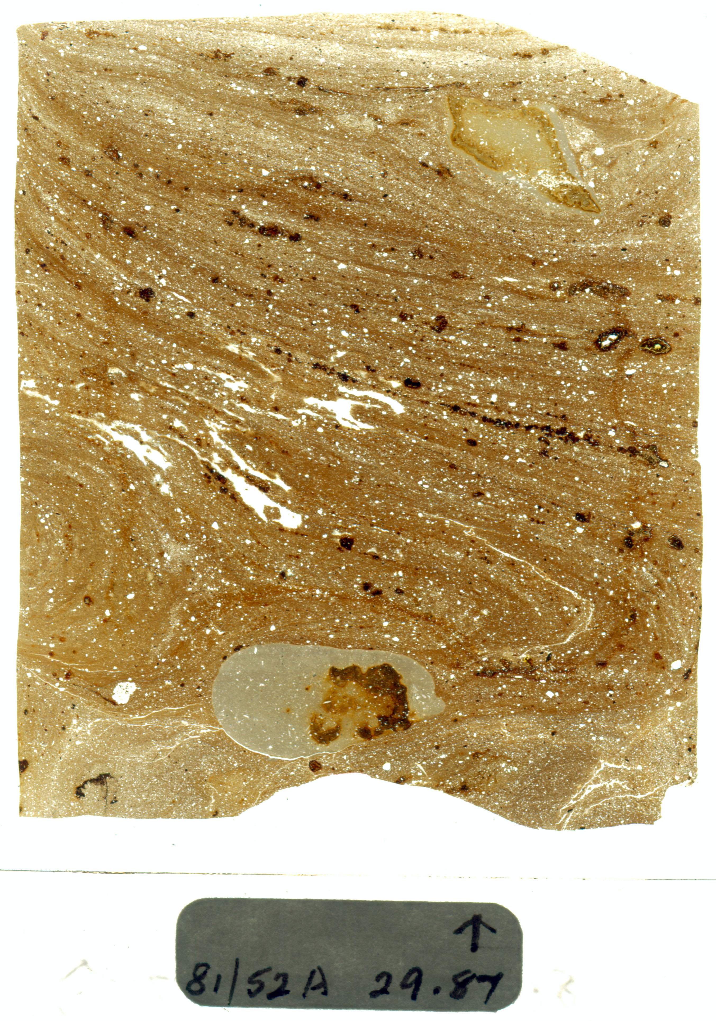
Glacial sediments
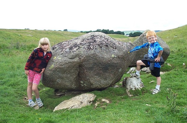
Subglacial sediments indicate whether the ice was wet-based or cold. The structures of subglacial deformation tell us about pore-water pressure, ice-flow direction, depth of deformation and more. We can use classic ‘indicator erratics’ (such as a specific granite like the Shap Granite) to trace ice flow back to a specific point source.
Post-glacial rebound
We can also use sea level change to reconstruct past ice sheet volume. In some places, like Scandinavia, Scotland and Antarctica, the land is rebounding following the last ice age. The huge weight of ice sheets in these areas during the last deglaciation depressed the Earth’s mantle. It is slowly responding to the removal of this massive weight by rebounding. If we can measure the rate of past and present sea level rise due to this isostatic uplift, and we know the viscosity of the mantle, we can make estimates of former ice volume in these areas.
Dating past glaciations
And then we have a number of chronological techniques that tell us how old these sediments and landforms are. Radiocarbon dating is frequently used on organic matter outside ice sheet margins. For example, after ice recession, a lake may form in the lee of a moraine. Sediments will collect in this lake, including pollen and bits of vegetation. A lake sediment core will give us a record of the Late Glacial, and a radiocarbon age at the base of the lake will give us a minimum age for ice recession. In Antarctica, marine sediment cores have been taken all across the continental shelf. The base of these cores is typically subglacial sediments, followed by ice-marginal glaciomarine sediments and then distal glaciomarine sediments. Radiocarbon ages on these transitional glaciomarine sediments gives palaeoglaciologists a minimum age for ice recession.
Cosmogenic nuclide dating dates the length of time that boulders or bedrock has been exposed to the atmosphere. The yield an exposure age; the age since the boulder or rock was left behind by the glacier. Sandy sediments, often deposited by glaciofluvial rivers just in front of the glacier, can yield a burial age: optically stimulated luminescence gives the time since burial. Together, with these and other techniques, palaeoglaciologists can understand the dimensions and change through time of past ice sheets. By comparing this data to records of past environmental change, for example ice cores from Greenland or marine sediment cores, they can investigate past ice-sheet response to atmospheric and oceanic forcing – the golden key that will unlock the future.

Computer simulations
The physics of glacier ice is reasonably well understood. We know the electrical conductivity of ice – so we know how its temperature changes with depth in the ice. We have laws that govern how ice deforms and moves. We have observations that tell us how much snow and ice melts for a given temperature. Together, we can input these mathematical equations into a computer programme. The computer programme will calculate the movement of ice through time. We can use this to investigate different ice flow under different environmental conditions.
Numerical modellers use these computer programmes to test hypotheses of past ice sheet behaviour generated by palaeoglaciologists. These palaeoglaciological data are used to improve these ice sheet models. Ultimately, the improved models are used to generate hypotheses of future ice sheet change under various carbon emissions scenarios. We can investigate how glaciers will behave under different air and ocean temperatures. By continuously working together to better understand past and present ice sheets, palaeoglaciologists reduce uncertainty and improve predictions of future sea level rise.
About the author
Dr Bethan Davies is a post-doctoral research associate at the Centre for Glaciology, Aberystwyth University, UK. She is currently analysing glacier response to climate change over centennial to millennial timescales, both in Antarctica and Patagonia. She uses a combination of field work, remotely sensed images and computer simulations to assess changes in glaciers. She blogs and writes about climate change and glaciers at www.AntarcticGlaciers.org.
References:
Davies et al, 2011: http://onlinelibrary.wiley.com/doi/10.1002/jqs.1426/full
Geograph.org.uk http://www.geograph.org.uk/photo/444936
